Alert+

Emergency Declared as Earthquake Devastates Sagaing and Mandalay
Intelligence cut off: 10:00 GMT 28 March 2025
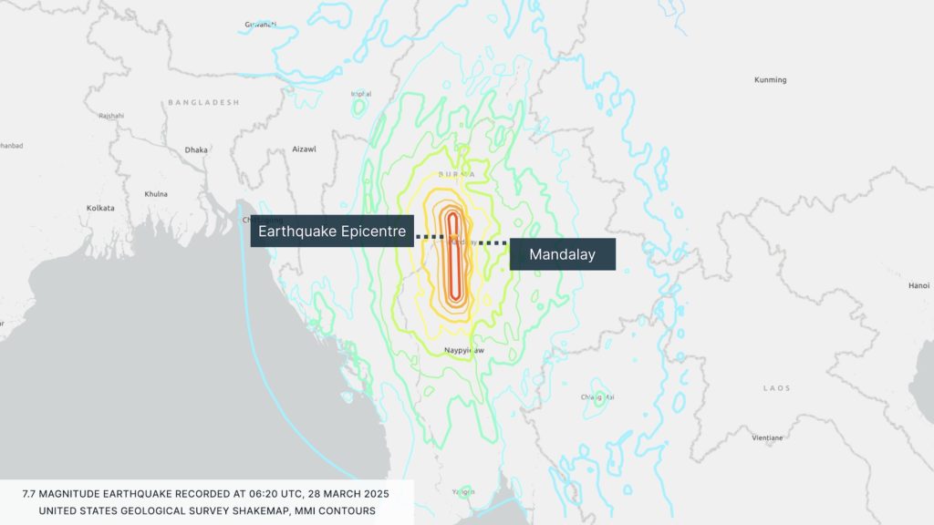
At 12:50 local time (06:20 UTC) on 28 March, a magnitude 7.7 earthquake struck the Sagaing Region of central Myanmar. The epicentre was located approximately 16 kilometres north-northwest of Sagaing City in Mandalay’s outskirts, at a depth of 10 kilometres. The main tremor was followed by several aftershocks of above 5.0 magnitude. The earthquake has caused widespread damage across the cities of Sagaing and Mandalay, with multiple high-rise buildings and bridges destroyed. Tremors have also been felt in neighbouring countries, including Vietnam, Bangladesh, China, and Thailand.
The impacts of the earthquake were felt strongly in Thailand, where shaking caused buildings to collapse in Bangkok. The Thai Prime Minister Paetongtarn Shinawatra declared a state of emergency within the first hours of the earthquake being felt and also ordered the evacuation of tall buildings in Bangkok, at least one of which collapsed while under construction. Communications were disrupted in Bangkok, and the Transport Ministry temporarily suspended flights nationwide for approximately 20 minutes; flights have since resumed. Train services were also suspended in the capital until further notice.
Official casualty figures are currently unclear. Myanmar’s military junta controls most radio, television, print, and online media; internet use is restricted; and communication lines are currently down. According to the US Geological Survey, thousands are likely dead as a result of the shaking, stating that ‘high casualties and extensive damage are probable, and the disaster is likely widespread.’ Myanmar’s national disaster management committee has declared a state of emergency in Sagaing, Mandalay, Magway, northeastern Shan State, Naypyitaw Council Area, and Bago.
Local reports have confirmed several casualties. In Mandalay, the collapse of a mosque resulted in 10 deaths, and several monks were injured when a monastery also collapsed. In Taungoo Township, a school collapse claimed the lives of five children, and 14 others died when a mosque collapsed. Two fatalities were reported in Pyawbwe Township following the collapse of both a mosque and a university building. In Taungoo Township, a school acting as a shelter for displaced people collapsed, trapping over 20 individuals. In Aungban, Shan, the collapse of a hotel killed two people and left 20 others trapped.
INTELLIGENCE ANALYSIS
Relief Efforts Hindered by Conflict, Terrain, and Aftershocks in Myanmar
The earthquake is the strongest in Myanmar in over 150 years. The last comparable tremor occurred in 2012 when a magnitude 6.8 earthquake struck near Shwebo, 120 kilometres north of Mandalay. The 2012 earthquake resulted in 26 fatalities: a toll almost certain to be considerably exceeded by the latest quake. North-central, south-central, and central Myanmar frequently experiences seismic activity due to their location within the convergence zone of the Indian and Sunda Plates, where tectonic stress is periodically released as earthquakes.
The Sagaing Fault is a major geological feature running north to south through central Myanmar, which likely explains why Bangkok was more affected than areas in Bangladesh. Its positioning induces east-west compression, leading to crustal shortening and uplift, while also generating north-south stress that drives lateral crustal movement. Given its proximity to Myanmar’s largest urban centres, including Mandalay and Yangon, the fault poses a significant risk of damage in the event of future seismic activity.
Several aftershocks have already been felt in Myanmar; further aftershocks are highly likely in the coming days. While the aftershocks are unlikely to reach a similar magnitude to the initial earthquake, further aftershocks of approximately 5.0 magnitude may still occur. This could further damage structures that have already been weakened by the initial tremor and hinder relief efforts.
A humanitarian crisis has been ongoing in the country since the military conducted a coup in February 2021, deposing the democratically elected government. Several resistance groups formed in the aftermath, triggering a civil war. Significant civilian casualties and widespread displacement have occurred as a result of the conflict, and the nation faces a worsening humanitarian crisis. The earthquake will almost certainly exacerbate the ongoing humanitarian crisis by disrupting power and water infrastructure, trade routes, and agriculture, which accounts for between 25 and 30 per cent of Myanmar’s GDP.
Given the mountainous topography of the region, limited capabilities of the authorities, and potential aftershocks, relief efforts will likely be hampered. This will likely be exacerbated by the ongoing conflict, whereby the military junta will almost certainly prioritise regime survival over humanitarian assistance, likely using limited resources to assist the affected regions not under its control. The government has implemented a state of emergency in the aftermath, which may be used to conduct arbitrary detentions, impose curfews, and censor media.
The likely limited assistance will almost certainly be exacerbated by the presence of rebel groups in Mandalay. These groups include Mandalay People’s Defence Force (PDF), Ta’ang National Liberation Front (TNLF), Myanmar National Democratic Alliance Army (MNDAA), and Burma National Revolutionary Army (BNRA). On 14 March, at least 27 people were killed and at least 30 injured after Myanmar’s military junta conducted an airstrike on Singu Township, Mandalay. It is likely that rebel groups will take advantage of the damaged infrastructure and communications networks in the region to capture government-held territory near Mandalay.
Travel Risk Advice: Safety Guidelines for Myanmar
- Closely monitor local news reports and government alerts.
- Expect aftershocks. Be prepared to Drop, Cover, Hold On in case of further tremors.
- During a tremor, if outside, do not enter buildings and move away from buildings, trees, streetlights and overhead lines.
- If inside, pick a safe place (under a sturdy table or desk or against an interior wall and away from windows and heavy furniture). Do not leave until the shaking stops.
- If evacuating a building, always use the stairs. Look out for fires and falling debris.
- Prepare an emergency ‘go bag’ with essentials such as bottled water, batteries, important documents, and medications.
- Confirm booked flights are running before checking out of hotels or travelling to the airport.
- Management should maintain communication with the individuals affected until the event is concluded.
- Heed evacuation orders and travel to government-issued shelters if it is safe to do so.
- Adhere to all instructions issued by authorities.
- Ensure important documents and medications are appropriately stored.
- Prepare for power outages, communication disruptions, and travel delays. Stay away from damaged buildings and affected areas until authorities deem them safe.